
Sights on Tour
We greatly appreciate more sightseeing suggestions in the comments!
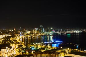

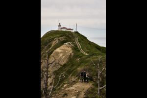
Baku
Baku (Azerbaijani: Bakı, IPA: [bɑˈcɯ]) is the capital and largest city of Azerbaijan, as well as the largest city on the Caspian Sea and of the Caucasus region. Baku is located 28 metres (92 ft) below sea level, which makes it the lowest lying national capital in the world and also the largest city in the world located below sea level. It is located on the southern shore of the Absheron Peninsula, which projects into the Caspian Sea.


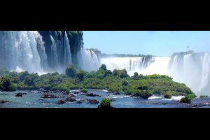

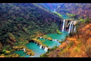
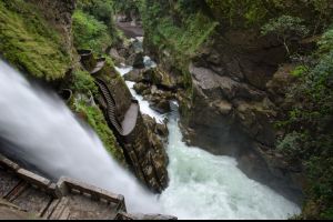
Iguacu Waterfalls
The Iguazu Falls in the border region between Brazil and Argentina are the biggest waterfalls in the world. The same National Park is part of the World Heritage of Unesco.
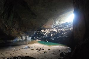
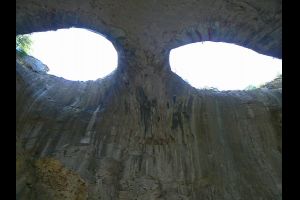
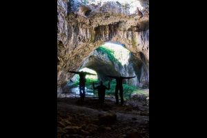
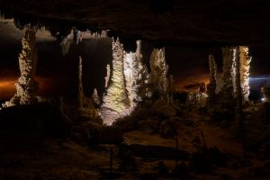
Hang Son Doong Cave
The Hang Son Doong in Vietnam is one of the largest cave of our planet and even has its own beaches and clouds.
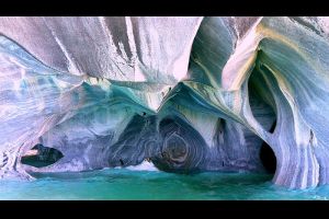
Catedral de Marmol
The so-called Marble Caves are pull through waves eye-washed limestone caves and overhangs, through which different colored marble veins. These form a spectacular play of colors with the already great Water color of the lake.
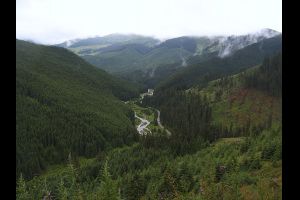
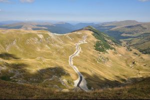
High Tatras national park
The High Tatras or High Tatra Mountains (Slovak and Czech: Vysoké Tatry, Polish: Tatry Wysokie), are a mountain range along the border of northern Slovakia in the Prešov Region, and southern Poland in the Lesser Poland Voivodeship. They are a range of the Tatra Mountains chain.
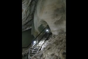
Dobšinská Ice Cave
Dobšinská Ice Cave or Dobšinská ľadová jaskyňa (in Slovak) is an ice cave in Slovakia, near the mining town of Dobšiná in the Slovak Paradise. Since 2000 it is included in the UNESCO World Heritage list as a part of Caves of Aggtelek Karst and Slovak Karst site.

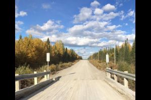
Volovets Pass
Volovets Pass is a mountain pass at an elevation of 1,014 m (3,327 ft) above the sea level, located in the north-eastern Carpathian Mountains of Ukraine. The road over the pass is extreme, and automobile traffic across the pass is impossible since the road is too difficult to traverse. The southern slope of the pass is steep, while the northern flank is declivous. It consists of sandstones and slates.
Prislop Pass
Prislop Pass (Romanian: Pasul Prislop) is a mountain pass in northern Romania, connecting the historical regions of Maramureş and Bukovina over the Rodna Mountains, in the Eastern Carpathians.
Transfagarasan
The Transfăgărășan (trans (over, across) + Făgăraș) or DN7C is the second-highest paved road in Romania after Transalpina. It starts near the village of Bascov, located near the city of Pitesti, ending on the crossroad between DN1 and Sibiu. Also known as Ceaușescu's Folly, it was built as a strategic military route that stretches 90 km with twists and turns that run north to south across the tallest sections of the Southern Carpathians, between the highest peaks in the country, Moldoveanu, and the second highest, Negoiu. The road connects the historic regions of Transylvania and Wallachia, and the cities of Sibiu and Pitești. According to Top Gear the Greates road in the world!
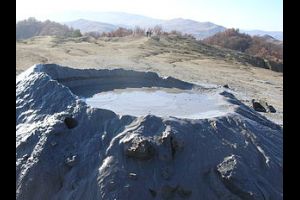
Berca Mud Volcanoes
The Berca Mud Volcanoes are a geological and botanical reservation located in the Berca commune in the Buzău County in Romania. Its most spectacular feature is the mud volcanoes, small volcano-shaped structures typically a few metres high caused by the eruption of mud and natural gases.
Cape Emine
Cape Emine (Bulgarian: Нос Емине) is a headland located at the Bulgarian Black Sea Coast. It is located 49 miles south of Varna, 34 miles north of Burgas and 9 miles south of Obzor. It forms the tip of Stara Planina. Cape Emine is said to be Bulgaria's stormiest cape.
In the Middle Ages, there was a fortress called Emona on Cape Emine. Its name was derived from Aemon, the ancient name for Stara Planina. Nowadays, only some ruins of the fortress are left. There are also remnants of a monastery and a lighthouse. The village of Emona is located nearby.
In the Middle Ages, there was a fortress called Emona on Cape Emine. Its name was derived from Aemon, the ancient name for Stara Planina. Nowadays, only some ruins of the fortress are left. There are also remnants of a monastery and a lighthouse. The village of Emona is located nearby.
Transalpina
Transalpina road (DN67C) or locally known as The Kings Road is the highest road in Romania. It’s one of the famous Romanian high altitude roads. With a length of 146 km, it goes trough the Carpathian Mountains, reaching a maximum altitude of 2,145m above sea level in Pasul Urdele. In 2009 it was completely paved.
Strandzha
Strandzha is a mountain massif in southeastern Bulgaria and the European part of Turkey, in the southeastern part of the Balkans between the plains of Thrace to the west, the lowlands near Burgas to the north and the Black Sea to the east. Its highest peak is Mahya Dağı (Bulgarian: Махиада, Mahiada) (1,031 m or 3,383 ft) in Turkey, while the highest point on Bulgarian territory is Golyamo Gradishte (Bulgarian: Голямо Градище) (710 m or 2,329 ft).
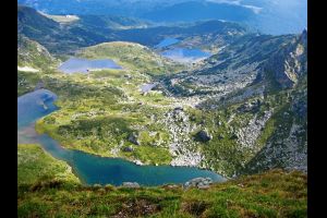
Seven Rila Lakes
The Seven Rila Lakes are a group of lakes of glacial origin (glacial lakes), situated in the northwestern Rila Mountains in Bulgaria. They are the most visited group of lakes in Bulgaria. The lakes are situated between 2,100 and 2,500 metres elevation above sea level.
Tbilisi
Tbilisi (Georgian: თბილისი [tʰˈbiliˌsi] ( listen)), formerly known as Tpilisi and Tiflis, is the capital and the largest city of Georgia, lying on the banks of the Mtkvari River with a population of roughly 1.5 million inhabitants. Founded in the 5th century by the monarch of Georgia's ancient precursor Kingdom of Iberia, Tbilisi has since served, with intermissions, as the Georgian capital.
Tehran
Tehran (تهران - Tehrān) is the capital of Iran and Tehran Province. With a population of around 8.4 million in the city and 14 million in the wider metropolitan area, Tehran is Iran's largest city and urban area, the largest city in Western Asia and one of the largest three cities in the Middle East (along with Istanbul and Cairo).

from January to January
from July to August
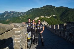

Great Wall of China
In terms of volume and mass, the Great Wall of China is considered the largest building in the world. Four sections can be visited by tourists. The most famous restored wall section is located at Badaling, 70 km northwest of Beijing. More sections available for tourists are at Mutianyu, Simatai and Juyongguan.
from June to September
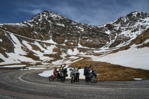
Abano Pass
Abano Pass (Georgian: აბანოს უღელტეხილი) is a mountain pass located in Georgia. At 2,850 metres (9,350 ft), it is the highest drivable mountain pass in the Caucasus.
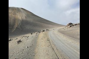
Bayburt of Yolu
D915 is one of the most challenging roads in the world. Located in the Trabzon province, Turkey, the road is extreme, bordered by a drop of hundreds of meters unprotected by guardrails, more dangerous than the famous Death Road.
It has a length of 106 km and includes 29 steep hairpins. The start and the end of the road are asphalted, but the central part is gravel. The road climbs up an elevation of 2,035m above the sea level, at Soganli Dagi.
It has a length of 106 km and includes 29 steep hairpins. The start and the end of the road are asphalted, but the central part is gravel. The road climbs up an elevation of 2,035m above the sea level, at Soganli Dagi.
Khovd-Ölgii
High mountain dirt track in Mongolia, linking the cities of Khovd and Ölgii, with a length of 212 km.
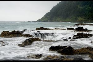
Thor's Well
Thor’s Well releases jets of water which are pumped into the air via the power of the ocean tide and waves. It is a popular spot for taking photos – though it is very risky specially at high tide and in winter time.
Both Thor's Well and Spouting Horn are best seen approximately an hour before high tide to an hour after high tide.
Both Thor's Well and Spouting Horn are best seen approximately an hour before high tide to an hour after high tide.
from April to September
Semo La Pass
Semo La is a high mountain pass at an elevation of 5,565 meters (18,259 ft) above the sea level, located in Tsochen county in Ngari Prefecture, in the central part of Tibet, in China. It gives access to the Chang Tang region. It may be the highest vehicle-accessible pass in the world.
from June to September
Marsimik La
Marsimik La is a high mountain pass at an elevation of 5,777 m (18,953 ft) above the sea level, located in the Chang-Chemno Range in northern India. It’s said to be the highest motorable pass in the world.
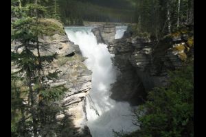
Athabasca Falls
A powerful, picturesque waterfall, Athabasca Falls is not known so much for the height of the falls (23 metres), as it is known for its force due to the large quantity of water falling into the gorge. Even on a cold morning in the fall, when river levels tend to be at their lowest, copious amounts of water flow over the falls.
from October to April
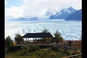
Parque Nacional Los Glaciares
The park's name refers to the giant ice cap in the Andes range that feeds 47 large glaciers, of which 13 flow towards the Atlantic Ocean. The ice cap is the largest outside of Antarctica and Greenland. In other parts of the world, glaciers start at a height of at least 2,500 m (8,200 ft) above mean sea level, but due to the size of the ice cap, these glaciers begin at only 1,500 m (4,900 ft), sliding down to 200 m (660 ft) Los Glaciares borders Torres del Paine National Park to the south in Chilean territory.
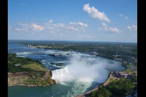
Niagara Falls
Located on the Niagara River, which drains Lake Erie into Lake Ontario, the combined falls form the highest flow rate of any waterfall in the world, with a vertical drop of more than 165 feet (50 m). Horseshoe Falls is the most powerful waterfall in North America, as measured by vertical height and also by flow rate.
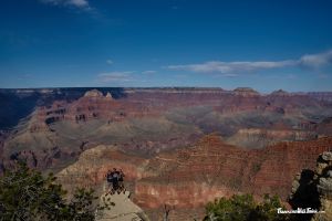
Grand Canyon
The Grand Canyon is 277 miles (446 km) long, up to 18 miles (29 km) wide and attains a depth of over a mile (6,093 feet or 1,857 meters). Nearly two billion years of Earth's geological history have been exposed as the Colorado River and its tributaries cut their channels through layer after layer of rock while the Colorado Plateau was uplifted.

Las Vegas
Las Vegas, officially the City of Las Vegas, is a city in the United States, the most populous city in the state of Nevada. Las Vegas is an internationally renowned major resort city known primarily for gambling, shopping, fine dining and nightlife and is the leading financial and cultural center for Southern Nevada.
from May to September
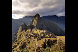
Machu Picchu
Machu Picchu is a 15th-century Inca site located 2,430 metres (7,970 ft) above sea level. It is located in the Cusco Region, Urubamba Province, Machupicchu District in Peru.
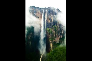
Angel Falls
Angel Falls (Spanish: Salto Ángel; Pemon language: Kerepakupai Vená) is a waterfall in Venezuela. It is the world's highest uninterrupted waterfall, with a height of 979 m and a plunge of 807 m. The waterfall drops over the edge of the Auyantepui mountain in the Canaima National Park (Spanish: Parque Nacional Canaima), a UNESCO World Heritage site in the Gran Sabana region of Bolívar State.
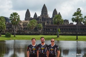
Angkor Wat
Angkor Wat (Khmer: អង្គរវត្ត or "Capital Temple") is a temple complex in Cambodia and the largest religious monument in the world. It was originally founded as a Hindu capital for the Khmer Empire, gradually transforming into a Buddhist temple toward the end of the 12th century. It was built by the Khmer King Suryavarman II in the early 12th century in Yaśodharapura, the capital of the Khmer Empire, as his state temple and eventual mausoleum.
Huangshan
Huangshan (simplified Chinese: 黄山; traditional Chinese: 黃山;) is a mountain range in southern Anhui province in eastern China. Vegetation on the range is thickest below 1,100 meters (3,600 ft), with trees growing up to the treeline at 1,800 meters (5,900 ft). The area is well known for its scenery, sunsets, peculiarly shaped granite peaks, Huangshan Pine trees, hot springs, winter snow, and views of the clouds from above.
from July to November
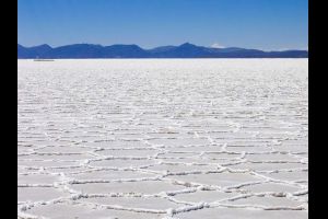
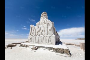
Salar de Uyuni
Salar de Uyuni (or Salar de Tunupa) is the world's largest salt flat at 10,582 square kilometers (4,086 sq mi). It is located in the Daniel Campos Province in Potosí in southwest Bolivia, near the crest of the Andes and is at an elevation of 3,656 meters (11,995 ft) above sea level.
When it rains the survace of the salt flat looks like a mirror!
When it rains the survace of the salt flat looks like a mirror!
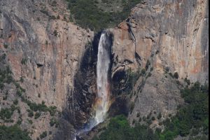
Bridalveil Fall
Bridalveil Fall is one of the most prominent waterfalls in the Yosemite Valley in California, seen yearly by millions of visitors to Yosemite National Park.[1] The waterfall is 188 metres (617 ft) in height and flows year round.
If the sun hits the waterfall at a certain angle it appears to glow in the colors of a rainbow.
If the sun hits the waterfall at a certain angle it appears to glow in the colors of a rainbow.
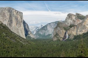
Yosemite National Park
Designated a World Heritage Site in 1984, Yosemite is internationally recognized for its spectacular granite cliffs, waterfalls, clear streams, giant sequoia groves, and biological diversity. Almost 95% of the park is designated wilderness. Yosemite was central to the development of the national park idea.
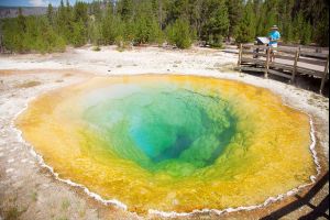
Yellowstone National Park
Yellowstone, widely held to be the first national park in the world (founded March 1st 1872), is known for its wildlife and its many geothermal features, especially Old Faithful Geyser, one of the most popular features in the park.[8] It has many types of ecosystems, but the subalpine forest is most abundant. It is part of the South Central Rockies forests ecoregion.
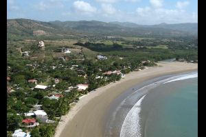

San Juan del Sur
A hit with surfers and backpackers, San Juan del Sur is the most popular beach destination in Nicaragua. All the beaches are beautiful and lapped by warm water. Here you’ll find great surfing (expect to pay around $9 USD per day for board rental and $25 per hour for lessons), the second-largest statue of Jesus in the world (behind Christ the Redeemer in Brazil), and lots of cheap bars. If you’re looking to party, this town is it. The two best hostels in town are The Naked Tiger and Pachamama (they throw a wild Sunday pool party too).
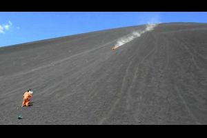
Volcano Boarding on Cerro Negro
Cerro Negro, a young and active volcano, is where tourists (mostly backpackers) board down the gravelly slopes on one of the many organized tours to the mountain. You hike up to the top, which takes around an hour, sit on a piece of wood, and then fly down side of the volcano. Tours from León leave in the morning and in the afternoon.
Gobi Gurvansaikhan
Gobi Gurvansaikhan National Park (Mongolian: Говь гурван сайхан байгалийн цогцолбор газар, Gobi three beauties nature complex) is a national park in southern Mongolia. The park was established in 1993, and expanded to its current size in 2000. The park, at nearly 27,000 square kilometres, is the largest national park in Mongolia, stretching 380 km from east to west and 80 km from north to south. Another major tourist destination is Yolyn Am, a mountain valley that contains a large ice field through most of the year.
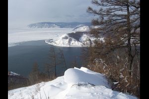
Lake Baikal
Lake Baikal is the largest (by volume) freshwater lake in the world, containing roughly 20% of the world's unfrozen surface fresh water, and at 1,642 m (5,387 ft), the deepest. It is also among the clearest of all lakes, and thought to be the world's oldest lake at 25 million years. It is the seventh-largest lake in the world by surface area. With 23,615.39 cubic kilometres (5,700 cubic miles) of fresh water, it contains more water than all the Great Lakes combined.
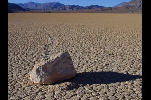
Death-Valley
Death Valley National Park is a national park in the U.S. states of California and Nevada located east of the Sierra Nevada, occupying an interface zone between the arid Great Basin and Mojave deserts in the United States. The park protects the northwest corner of the Mojave Desert and contains a diverse desert environment of salt-flats, sand dunes, badlands, valleys, canyons, and mountains. It is the largest national park in the lower 48 states and has been declared an International Biosphere Reserve.
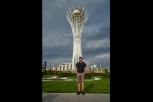
Astana
Astana is the capital of Kazakhstan. It is located on the Ishim River in the north portion of Kazakhstan, within Akmola Region, though administrated separately from the region as a city with special status. The 2014 census reported a population of 835,153 within the city, making it the second-largest city in Kazakhstan.
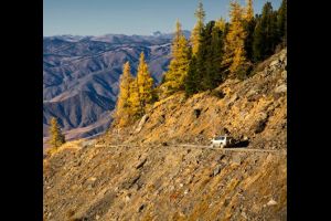
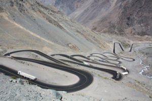
Burkhatskiy Pass
The road is famous for its beauty. It’s 50 km (5 hours) long, from Markakol Lake to Burkhat pass. It’s a really difficult road, crossing 16 bridges and fords and never ending hairpin turns. The road is winding, in some places only wide enough for one vehicle, and in many places bordered by a drop of hundreds of meters (many hundreds of feet) unprotected by guardrails. Words can’t describe the road and pictures don’t do it justice.
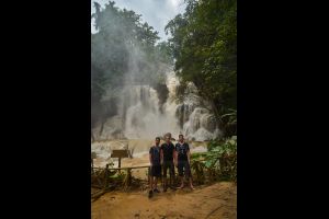
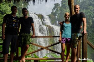
Kuang Si Falls
These waterfalls are a favourite side trip for tourists in Luang Prabang. The falls begin in shallow pools atop a steep hillside. These lead to the main fall with a 60 metres cascade. The falls are accessed via a trail to a left of the falls. The water collects in numerous turquoise blue pools as it flows downstream.
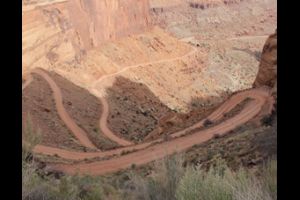
White Rim Road
The White Rim Road is a one hundred mile long unimproved, off-road vehicle route through the White Rim bench lands below the upper plateau of the Island in the Sky District between the Colorado and Green Rivers, in the Canyonlands National Park, located in southeastern Utah near the town of Moab, USA.
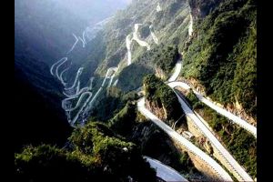
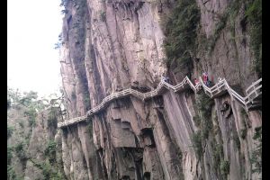
Tian Men Shan Big Gate Rd
Tianmen Shan Big Gate (also called the Tianmen Winding Mountain Road) is a road located within Tianmen Mountain National Park, Zhangjiajie, in northwestern Hunan Province, China. In 11 kilometers 99 turns!
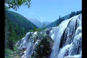
Pearl Shoal Waterfall
Pearl Shoal Waterfall is a waterfall located in Aba-Ngawa Tibetan and Qiang Autonomous Prefecture in northern Sichuan Province. The waterfall exists on one of the tributaries of the Bailong Jiang (White Dragon River).
Located in Jiuzhaigou, at an altitude of 2,433 metres, the top of the waterfall is 162.5 metres in width. It has a fall of 40 metres.
Located in Jiuzhaigou, at an altitude of 2,433 metres, the top of the waterfall is 162.5 metres in width. It has a fall of 40 metres.

Orange County Choppers
Orange County Choppers, Inc. (kurz OCC) ist ein US-amerikanischer Motorradhersteller, der sich auf Chopper-Sonderanfertigungen spezialisiert hat. International bekannt wurde das Unternehmen durch die Fernsehserie American Chopper.
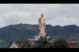
Spring Temple Buddha
The Spring Temple Buddha (Chinese: 中原大佛 and simplified Chinese: 鲁山大佛; traditional Chinese: 魯山大佛) is a statue depicting Vairocana Buddha located in the Zhaocun township of Lushan County, Henan, China, built from 1997 to 2008. At 128 m (420 ft), which includes a 20 m (66 ft) lotus pedestal, it is the tallest statue in the world.
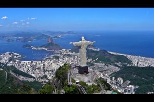
Christ the Redeemer (statue)
Christ the Redeemer (Portuguese: Cristo Redentor, standard Brazilian Portuguese: [ˈkɾistu ʁedẽˈtoʁ], local dialect: [ˈkɾiʃtu ɦedẽjˈtoɦ]) is an Art Deco statue of Jesus Christ in Rio de Janeiro, Brazil, created by French sculptor Paul Landowski and built by the Brazilian engineer Heitor da Silva Costa, in collaboration with the French engineer Albert Caquot. It is 30 metres (98 ft) tall, not including its 8-metre (26 ft) pedestal, and its arms stretch 28 metres (92 ft) wide.

Golden Gate Bridge
The Golden Gate Bridge is a suspension bridge spanning the Golden Gate strait, the mile-wide, three-mile-long channel between San Francisco Bay and the Pacific Ocean. The structure links the U.S. city of San Francisco, on the northern tip of the San Francisco Peninsula, to Marin County, bridging both U.S. Route 101 and California State Route 1 across the strait. The bridge is one of the most internationally recognized symbols of San Francisco, California, and the United States. It has been declared one of the Wonders of the Modern World by the American Society of Civil Engineers.
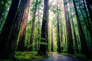
Redwood National and State Parks
The Redwood National and State Parks (RNSP) are old-growth temperate rainforests located in the United States, along the coast of northern California. Located entirely within Del Norte and Humboldt Counties, the four parks, together, protect 45% of all remaining coast redwood (Sequoia sempervirens) old-growth forests, totaling at least 38,982 acres (157.75 km²). These trees are the tallest and one of the most massive tree species on Earth.

Mount Rushmore
Mount Rushmore National Memorial is a sculpture carved into the granite face of Mount Rushmore (Lakota Sioux name: Six Grandfathers) near Keystone, South Dakota, in the United States. Sculpted by Danish-American Gutzon Borglum and his son, Lincoln Borglum, Mount Rushmore features 60-foot (18 m) sculptures of the heads of four United States presidents: George Washington (1732–1799), Thomas Jefferson (1743–1826), Theodore Roosevelt (1858–1919), and Abraham Lincoln (1809–1865).
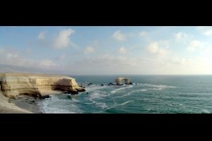
La Portada
La Portada (Spanish: "The Gateway") is a natural arch on the coast of Chile, 18 km (11 mi) north of Antofagasta. It is one of fifteen natural monuments included among the protected areas of Chile.
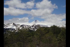
Villarica Volcano
Villarrica National Park is located in the Andes, in the La Araucanía and Los Ríos regions of Chile, near Pucón. The centerpiece of the park is a line of three volcanoes stretching transversely to the Andean range: Villarrica, Quetrupillán, and Lanín.
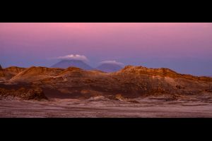
Valle de La Luna
El Valle de la Luna (Valley of the Moon) is located 13 kilometres (8 mi) west of San Pedro de Atacama, Chile in the Cordillera de la Sal, in the Atacama desert of Chile. It has various stone and sand formations which have been carved by wind and water. It has an impressive range of color and texture, looking somewhat similar to the surface of the moon.
The Paramount Road
The road to lake Paron is located in the Cordillera Blanca mountain range, a part of the Peruvian Andes. The drive offers dramatic mountain views of the Chacraraju, Pisco, Huandoy mountains and the iconic Artesonraju. It has been suggested that Artesonraju is the mountain depicted in the live-action Paramount Pictures logo.
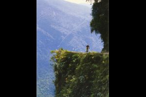
Death Road
La Carretera de los Yungas is, probably, the most famous road in the world as well as one of the most dangerous. This gravel dirt track covers a 69-kilometre (43 mi) stretch between La Paz and Coroico, in the Yungas region of Bolivia. It is the black widow of roads. It is notorious for being the most treacherous stretch of road in the world as threats of landslides and the 1000 meter cliff faces pose serious danger while traveling its slick and rocky path.

Door County Coastal Byway
Door County Coastal Byway is a scenic byway with a length of 66 miles located in Door County, a county in the U.S. state of Wisconsin. The road follows highways 42 and 57 around the peninsula.
It twists and turns like a snake, offering views of winding road and brilliant fall leaves. Photographers love this spot, especially in the fall because the road is dripping with a mixture of northern hardwood, aspen and oak tress, with a few pine trees sprinkled in for a touch of green.
It twists and turns like a snake, offering views of winding road and brilliant fall leaves. Photographers love this spot, especially in the fall because the road is dripping with a mixture of northern hardwood, aspen and oak tress, with a few pine trees sprinkled in for a touch of green.
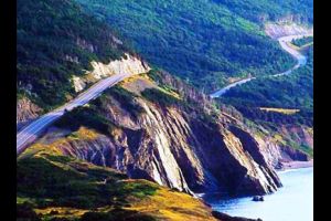
Cabot Trail
The Cabot Trail in Nova Scotia, Canada, is one of the most scenic drives in the world.
The route is 298 km (185 mi) long. It’s open all year round and completes a loop around the northern tip of the island, passing along and through the scenic Cape Breton Highlands. Besides the natural beauty to be found here, the Cabot Trail immerses you in the still vibrant Gaelic and Acadian cultures of Cape Breton.
The route is 298 km (185 mi) long. It’s open all year round and completes a loop around the northern tip of the island, passing along and through the scenic Cape Breton Highlands. Besides the natural beauty to be found here, the Cabot Trail immerses you in the still vibrant Gaelic and Acadian cultures of Cape Breton.
Northern Ontario Resource Trail
The Northern Ontario Resource Trail is a gravel road located in the Canadian province of Ontario. The road is 236.9 km (147.2 mi) long. The road travels north from Pickle Lake to the northern shore of Windigo Lake, in the northernmost community in the province which has year-round highway access.
Nevado del Ruiz
Nevado del Ruiz is a volcano located in Colombia, at an elevation of 5,321 m (17,457 ft) above sea level. A sudden drop in the temperature, even in summer, can trigger winter-like conditions. The drive to approach the volcano is the highest road in the country.
The road to reach the Nevado del Ruiz starts asphalted in Manizales, in the Caldas province, and gets worse everytime. At Parador Turístico La Esperanza (4.117m) there’s a barrier, which can be closed anytime if there’s some volcano risk. After this point 4x4 with high clearance is recommended.
The road to reach the Nevado del Ruiz starts asphalted in Manizales, in the Caldas province, and gets worse everytime. At Parador Turístico La Esperanza (4.117m) there’s a barrier, which can be closed anytime if there’s some volcano risk. After this point 4x4 with high clearance is recommended.
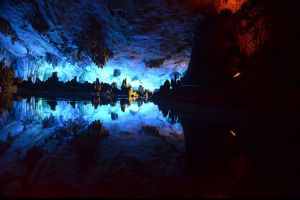
Reed Flute Cave
The Reed Flute Cave (Chinese: 芦笛岩; pinyin: Lúdí Yán) is a landmark and tourist attraction in Guilin, Guangxi, China. It is a natural limestone cave with multicolored lighting and has been one of Guilin’s most interesting attractions for over 1200 years. It is over 180 million years old. The cave got its name from the type of reed growing outside, which can be made into melodious flutes.
Sichuan-Tibet Highway
The Sichuan-Tibet Highway is a high-elevation road that begins in Chengdu of Sichuan on the east and ends at Lhasa in Tibet on the west. The road has a length of 2,142km.
The Sichuan-Tibet Highway, originally called the Kangding-Tibet Highway takes you through vast, open landscapes with majestic peaks vaulting skyward. The plateau areas are dotted with castellated Tibetan homes and an infinite number of contentedly munching yaks.
The Sichuan-Tibet Highway, originally called the Kangding-Tibet Highway takes you through vast, open landscapes with majestic peaks vaulting skyward. The plateau areas are dotted with castellated Tibetan homes and an infinite number of contentedly munching yaks.
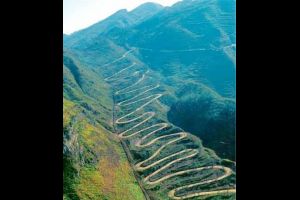
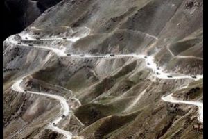
24-Zig Road
The 24-Zig Road is one of the most spectacular roads in China. This winding mountain road is located near Qinglong town in Guizhou Province, in the southwest of the country. It’s one of the most famous hairpin turns roads in the world.
The road is gravel. It was built during WW-II, and played an important role in the supply of China during the war to help resist the Japanese invasion. At present the road is no longer in active use but is still used as a shortcut by motorbikes and three-wheelers.
The road is gravel. It was built during WW-II, and played an important role in the supply of China during the war to help resist the Japanese invasion. At present the road is no longer in active use but is still used as a shortcut by motorbikes and three-wheelers.


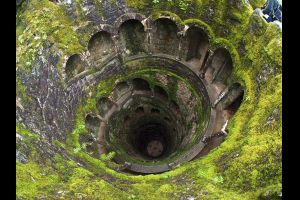
Quinta da Regaleira
Quinta da Regaleira is an estate located near the historic center of Sintra, Portugal. It is classified as a World Heritage Site by UNESCO within the "Cultural Landscape of Sintra". Along with the other palaces in the area (such as the Sintra National Palace, Pena, Monserrate and Seteais palaces), it's considered one of the principal tourist attractions of Sintra. The property consists of a romantic palace and chapel, and a luxurious park that features lakes, grottoes, wells, benches, fountains, and a vast array of exquisite constructions.
Devil's Bathtub
Scenic, 3-mile out-and-back hike to the Devil's Bathtub, a scoured rock formation within Devil's Fork Creek. Hike follows the creek closely along its entire course, crossing the creek multiple times and passing several scenic swimming holes, rock formations, and waterfalls.
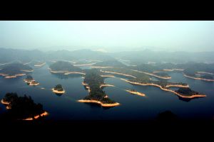
Qiandao Lake
Qiandao Lake (Chinese: 千岛湖, lit. Thousand Island Lake), a man-made lake located in Chun'an County, Zhejiang Province, China, was formed after the completion of the Xin'an River hydroelectric station in 1959. 1,078 large islands dot the lake and a few thousand smaller ones are scattered across it. The lake covers an area of 573 km² and has a storage capacity of 17.8 km³. The islands in the lake cover about 86 km².
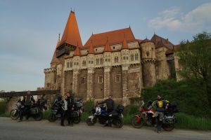
Corvin Castle
Corvin Castle, also known as Hunyadi Castle or Hunedoara Castle (Romanian: Castelul Huniazilor or Castelul Corvinilor), is a Gothic-Renaissance castle in Hunedoara, Romania. It is one of the largest castles in Europe and figures in a top of seven wonders of Romania.
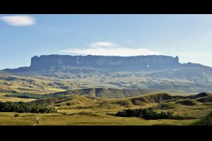
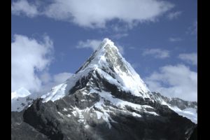
Mount Roraima
Mount Roraima lies on the Guiana Shield in the southeastern corner of Venezuela's 30,000-square-kilometre (12,000 sq mi) Canaima National Park forming the highest peak of Guyana's Highland Range. The tabletop mountains of the park are considered some of the oldest geological formations on Earth, dating back to some two billion years ago in the Precambrian.
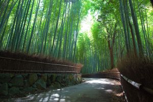
Arashiyama Bamboo Groves
The walking paths that cut through the bamboo groves make for a nice walk or bicycle ride. The groves are particularly attractive when there is a light wind and the tall bamboo stalks sway gently back and forth. The bamboo has been used to manufacture various products, such as baskets, cups, boxes and mats at local workshops for centuries. The Iwatayama Monkey Park is next to it.
from August to November
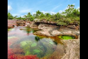
Caño Cristales
The river is commonly called the "River of Five Colors" or the "Liquid Rainbow", and is even referred to as the most beautiful river in the world due to its striking colors. The bed of river in the end of July through November is variously colored yellow, green, blue, black, and especially red, the last caused by the Macarenia clavigera (Podostemaceae) on the bottom of the river. It's a tributary of the Guayabero River.
from September to October
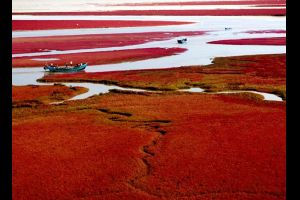
Red Beach Panjin
Red Beach (Chinese: 红海滩), located in Dawa County, Panjin,Liaoning, China, is famous for its landscape featuring the red plant of Suaeda salsa of the Chenopodiaceae family. It is based in the biggest wetland and reed marsh in the world. The landscape is composed of shallow seas and tide-lands.
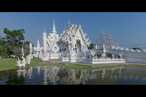
Wat Rong Khun
Wat Rong Khun (Thai: วัดร่องขุ่น), perhaps better known to foreigners as the White Temple, is a contemporary, unconventional, privately owned, art exhibit in the style of a Buddhist temple in Chiang Rai Province, Thailand. It is owned by Chalermchai Kositpipat, who designed, constructed, and opened it to visitors in 1997. It is open all year round and there is no charge for admission.
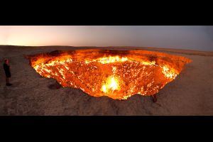
Door to Hell
The Door to Hell (also known as the Gates to Hell, the Crater of Fire, Darvaza Crater) is a natural gas field in Derweze, Turkmenistan, that collapsed into an underground cavern in 1971, becoming a natural gas crater. Geologists set it on fire to prevent the spread of deadly methane gas, and it has been burning continuously since then. The diameter of the crater is 69 m, and its depth is 30 m.
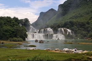
Bản-Giốc–Detian Falls
Ban Gioc – Detian Falls (Vietnamese: thác Bản Giốc, Chinese: Détiān pùbù, Bǎnyuē pùbù 板約瀑布, 德天瀑布) is a collective name for two waterfalls on the Quây Sơn River (Chinese: Guichun River, 归春河), that straddle the international border between China and Vietnam; more specifically located between the Karst hills of Daxin County, Guangxi, and Trùng Khánh District, Cao Bằng Province. The waterfall is 272 km (169 mi) north of Hanoi.
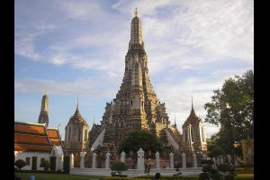
Wat Arun
Wat Arun Ratchawararam Ratchawaramahawihan or Wat Arun (Thai pronunciation: [wát ʔarun], "Temple of Dawn") is a Buddhist temple (wat) in Bangkok Yai district of Bangkok, Thailand, on the Thonburi west bank of the Chao Phraya River. The temple derives its name from the Hindu god Aruna, often personified as the radiations of the rising sun. Wat Arun is among the best known of Thailand's landmarks and the first light of the morning reflects off the surface of the temple with pearly iridescence. Although the temple had existed since at least the seventeenth century, its distinctive prang (spires) were built in the early nineteenth century during the reign of King Rama II.
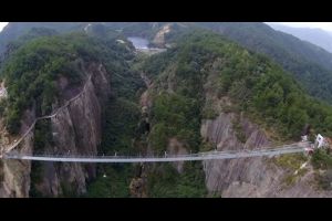
World's longest glass walkway
The land is known for its dramatic jagged rock formations and rich vegetation. If it looks like a scene out of Avatar, that’s because it is. The area, in the northwest part of Hunan province, was director James Cameron’s inspiration for the movie’s Halleluja Mountain.
When the Zhangjiajie Grand Canyon Glass Bridge opens in the fall, it will be the longest glass pedestrian bridge in the world. The structure stretches from one rocky summit to the next with little apparent effort. The bridge seems to float 1,300 feet above the ground, almost as though it were part of the clouds.
When the Zhangjiajie Grand Canyon Glass Bridge opens in the fall, it will be the longest glass pedestrian bridge in the world. The structure stretches from one rocky summit to the next with little apparent effort. The bridge seems to float 1,300 feet above the ground, almost as though it were part of the clouds.
from April to October
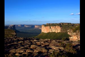
Chapada Diamantina National Park
Everything is extraordinary in Chapada. This land of gold and diamond stands out from the rest of the world's natural parks for two main reasons: its prodigious caverns with their pools of magical colors (although the most outstanding ones are not technically included within the boundaries of the park), and second, the hundreds of wonderful waterfalls splashed across its territory.
Gobi Destert
The Gobi is a large desert region in Asia. It covers parts of northern and northwestern China, and of southern Mongolia. The desert basins of the Gobi are bounded by the Altai Mountains and the grasslands and steppes of Mongolia on the north, by the Taklamakan Desert to the West, by the Hexi Corridor and Tibetan Plateau to the southwest, and by the North China Plain to the southeast. The Gobi is most notable in history as part of the great Mongol Empire, and as the location of several important cities along the Silk Road.
Grutas Tolantongo
After exploring you will absolutely want to soak once more in the purest water of the hot springs while surveying the vast mountains of Mexico. Forget about the cold! These springs are naturally warm and inviting. They are also said to be a source of magic-like minerals that will cure even the strongest winter blues. You can even camp directly next to the warm river!
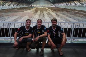
Terracotta warriors
The Terracotta Army or the "Terracotta Warriors and Horses" is a collection of terracotta sculptures depicting the armies of Qin Shi Huang, the first Emperor of China. It is a form of funerary art buried with the emperor in 210–209 BCE and whose purpose was to protect the emperor in his afterlife.
Pailon del Diablo
This gigantic waterfall is exceedingly attractive and allures millions of tourists every year from all over the world. Many tourists prefer to walk from the city to the waterfall. The town of Banos is forty minutes away from the waterfall and is located on the Pastaza River. There is a suspension bridge near to the waterfall and a little amount is collected from the tourists so that they can walk over the bridge. The view of waterfall is heavenly from the bridge. Owing to the fact that the whole area is somewhat humid but in a pleasant way, tourists might get drenched with sweat.
Devetàshka cave
Devetàshka cave (Bulgarian: Деветашката пещера) is a huge karst cave 7 kilometers from Letnitsa and 15 km northeast of Lovech, near the village of Devetaki on the east bank of the river Osam, in Bulgaria. It is known for its long term occupancy for human and other type biological populations during extensive historical periods, and also home to nearly 30,000 bats. The Expendables 2 was filmed here in 2011.
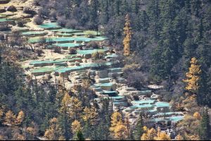
Huanglong
Huanglong (simplified Chinese: 黄龙; traditional Chinese: 黃龍) is a scenic and historic interest area in the northwest part of Sichuan, China. This area is known for its colorful pools formed by calcite deposits, especially in Huanglonggou (Yellow Dragon Gully), as well as diverse forest ecosystems, snow-capped peaks, waterfalls and hot springs. Huanglong is also home to many endangered species including the giant panda and the Sichuan golden snub-nosed monkey. Huanglong was declared a World Heritage Site by UNESCO in 1992.
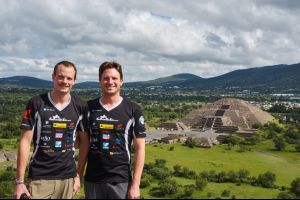
Teotihuacan
Teotihuacan was an ancient Mesoamerican city located in a sub valley of the Valley of Mexico, located in the State of Mexico 30 miles (48 km) northeast of modern-day Mexico City, known today as the site of many of the most architecturally significant Mesoamerican pyramids built in the pre-Columbian Americas.
The site covers a total surface area of 83 square kilometres and was designated a UNESCO World Heritage Site in 1987. It is the most visited archaeological site in Mexico.
The site covers a total surface area of 83 square kilometres and was designated a UNESCO World Heritage Site in 1987. It is the most visited archaeological site in Mexico.
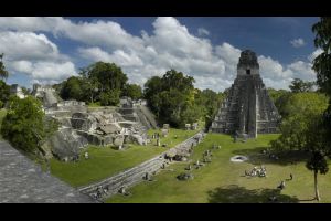
Tikal
Tikal is the ruins of an ancient city found in a rainforest in Guatemala. It is one of the largest archaeological sites and urban centers of the pre-Columbian Maya civilization. Situated in the department of El Petén, the site is part of Guatemala's Tikal National Park and in 1979 it was declared a UNESCO World Heritage Site.
Paso de los Libertadores
Chile and Argentina share more than 5,000 miles of border, most of them drawn on the imposing peaks of the Andes. With over 40 border crossings between the two countries spread over the mountains, the most spectacular and important is Paso de los Libertadores, also known as the Paso del Cristo Redentor. It's one of the most scenic drives in the world.
from June to September
Pamir Highway
The M41, known informally and more commonly as the Pamir Highway is a road traversing the Pamir Mountains through Afghanistan, Uzbekistan, Tajikistan, and Kyrgyzstan in Central Asia. It is the only continuous route through the difficult terrain of the mountains and serves as the main supply route to Tajikistan's Gorno-Badakhshan Autonomous Region. The route has been in use for millennia, as there are a limited number of viable routes through the high Pamir Mountains. The road formed one link of the ancient Silk Road trade route.
Blue Lake (Khar Zurkhnii Khukh Nuur Lake)
The Lake where Genghis Khan became the great Khan.
Genghis Khan (1162 – August 18, 1227, born Temüjin, was the founder and Great Khan (Emperor) of the Mongol Empire, which became the largest contiguous empire in history after his death.
Genghis Khan (1162 – August 18, 1227, born Temüjin, was the founder and Great Khan (Emperor) of the Mongol Empire, which became the largest contiguous empire in history after his death.
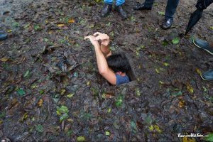
Cu Chi tunnels
The tunnels of Củ Chi (See Onetrip Cu Chi Adventure) are an immense network of connecting underground tunnels located in the Củ Chi District of Ho Chi Minh City (Saigon), Vietnam, and are part of a much larger network of tunnels that underlie much of the country. The Củ Chi tunnels were the location of several military campaigns during the Vietnam War, and were the Viet Cong's base of operations for the Tết Offensive in 1968.

Mui Ne
Mũi Né is a coastal fishing town in the Bình Thuận Province of Vietnam. The town, with approximately 25,000 residents is a ward of the city of Phan Thiết. Mui Ne and the other wards of Phan Thiet that stretch along the coast for approximately 50 kilometers have been transformed into a resort destination since the mid 1990s, when many visited the area to view the solar eclipse of October 24, 1995. Most notably, tourism has developed in the area from the city center to Mũi Né, which has more than a hundred beach resorts, as well as restaurants, bars, shops and cafes.
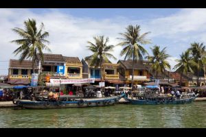
Hoi An
Hội An, formerly known as Fai-Fo or Faifoo, is a city with a population of approximately 120,000 in Vietnam's Quảng Nam Province and noted since 1999 as a UNESCO World Heritage Site.
Old Town Hội An, the city's historic district, is recognized as an exceptionally well-preserved example of a South-East Asian trading port dating from the 15th to the 19th century, its buildings and street plan reflecting a unique blend of influences, indigenous and foreign. Prominent in the city's old town, is its covered "Japanese Bridge," dating to the 16th-17th century.
Old Town Hội An, the city's historic district, is recognized as an exceptionally well-preserved example of a South-East Asian trading port dating from the 15th to the 19th century, its buildings and street plan reflecting a unique blend of influences, indigenous and foreign. Prominent in the city's old town, is its covered "Japanese Bridge," dating to the 16th-17th century.
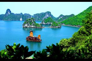
Ha Long Bay
Hạ Long Bay is a UNESCO World Heritage Site and popular travel destination in Quảng Ninh Province, Vietnam. Administratively, the bay belongs to Hạ Long City, Cẩm Phả town, and is a part of Vân Đồn District. The bay features thousands of limestone karsts and isles in various shapes and sizes. Hạ Long Bay is a center of a larger zone which includes Bái Tử Long Bay to the northeast, and Cát Bà Island to the southwest. These larger zones share a similar geological, geographical, geomorphological, climate and cultural characters.

War renmants Museum
The War Remnants Museum once known as the ‘Museum of American War Crimes’ first opened to the public in 1975.
It’s a shocking reminder of the long and brutal Vietnam War with many graphic photographs and American military equipment on display, including a helicopter with rocket launchers, a tank, a fighter plane, a single-seater attack aircraft and a 6,800kg conventional bomb.
It’s a shocking reminder of the long and brutal Vietnam War with many graphic photographs and American military equipment on display, including a helicopter with rocket launchers, a tank, a fighter plane, a single-seater attack aircraft and a 6,800kg conventional bomb.
Kong Lor Cave
Tham Kong Lo or Kong Lor Cave is a karst limestone cave in Phu Hin Bun National Park, in Khammouane Province, Laos. It is located roughly 130 kilometres (81 mi) north of Thakhek, on the Nam Hin Bun River, which flows into the cave. The karst formation is dramatic and the cave has been cited as a "one of Southeast Asia's geological wonders".
The cave is deep (lasting about 7 kilometres (4.3 mi)) and wide and as high as 300 feet in parts. The locals in recent years have set up vendors at the location to provide to tourists. Inside the cave is a pool which glows a bright emerald colour which locals hold as sacred, believing it to reflect the skin of the Hindi god Indra.
The cave is deep (lasting about 7 kilometres (4.3 mi)) and wide and as high as 300 feet in parts. The locals in recent years have set up vendors at the location to provide to tourists. Inside the cave is a pool which glows a bright emerald colour which locals hold as sacred, believing it to reflect the skin of the Hindi god Indra.
Luang Prabang
Luang Prabang is a city in north central Laos, consisting of 58 adjacent villages, of which 33 comprise the UNESCO Town Of Luang Prabang World Heritage Site. It was listed in 1995 for unique and "remarkably" well preserved architectural, religious and cultural heritage, a blend of the rural and urban developments over several centuries, including the French colonial influences during the 19th and 20th centuries. The center of the designated unesco town consists of 4 main roads and is located on a peninsula at the confluence of the Nam Khan and Mekong River.
Bolaven Plateau
The Bolaven Plateau is an elevated region in southern Laos. Most of the plateau is located within Champasak Province of Laos, though the edges of the plateau are also located in Sekong and Attapeu Provinces. It is located between the Annamite Mountain Range, along which runs Laos’ eastern border with Vietnam, and the Mekong River to the west. The plateau's elevation ranges approximately from 1,000 to 1,350 metres (3,280 to 4,430 ft) above sea level. The plateau is crossed by several rivers and has many scenic waterfalls. The name Bolaven makes reference to the Laven ethnic group which has historically dominated the region.
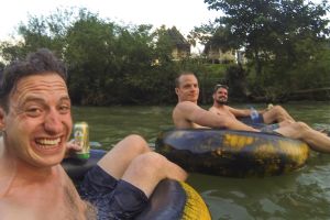
Vang Vieng Tubing
It's quite simple, you get in a tube, flow down the river and stop at several bars ;)
Si Phan Don (Four Thousand Islands)
The Si Phan Don (meaning The 4000 islands) is a riverine archipelago located in the Mekong River, Champasak Province in southern Laos. Si Phan Don is characterised by numerous islands, half of which are submerged when the Mekong River is in flood. The principal islands of Si Phan Don are Don Khong (the largest), and Don Det and Don Khon.
Killing Fields
The Killing Fields are a number of sites in Cambodia where collectively more than a million people were killed and buried by the Khmer Rouge regime, during its rule of the country from 1975 to 1979, immediately after the end of the Cambodian Civil War (1970–1975). The mass killings are widely regarded as part of a broad state-sponsored genocide (the Cambodian genocide).
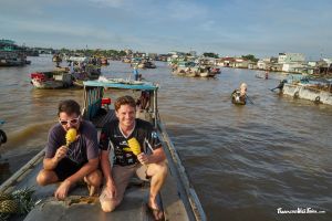
Cần Thơ (floating market)
Cần Thơ is the fourth-largest city in Vietnam, and the largest city in the Mekong Delta. It is noted for its floating market, rice paper-making village, and picturesque rural canals. It had a population of 1.2 million as of 2011, and is located on the south bank of the Hau River, a distributary of the Mekong river. In 2007, about 50 people died when the Cần Thơ Bridge collapsed, causing Vietnam's worst engineering disaster.
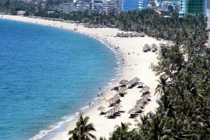
Nha Trang
Nha Trang is a coastal city and capital of Khánh Hòa Province, on the South Central Coast of Vietnam. It is bounded on the north by Ninh Hoà district, on the south by Cam Ranh town and on the west by Diên Khánh District. The city has about 392,000 inhabitants, a number that is projected to increase to 560,000 by 2015 and 630,000 inhabitants by 2025.
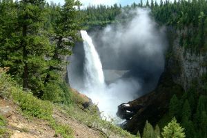
Helmcken Falls
Helmcken Falls is a 141 m (463 ft) waterfall on the Murtle River within Wells Gray Provincial Park in British Columbia, Canada.
Helmcken Falls is the fourth highest waterfall in Canada, measured by total straight drop without a break.
Helmcken Falls is the fourth highest waterfall in Canada, measured by total straight drop without a break.
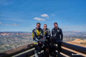
Bryce Canyon National Park
Bryce Canyon National Park /ˈbraɪs/ is a National Park located in southwestern Utah in the United States. The major feature of the park is Bryce Canyon, which despite its name, is not a canyon, but a collection of giant natural amphitheaters along the eastern side of the Paunsaugunt Plateau. Bryce is distinctive due to geological structures called hoodoos, formed by frost weathering and stream erosion of the river and lake bed sedimentary rocks. The red, orange, and white colors of the rocks provide spectacular views for park visitors. Bryce sits at a much higher elevation than nearby Zion National Park. The rim at Bryce varies from 8,000 to 9,000 feet (2,400 to 2,700 m).
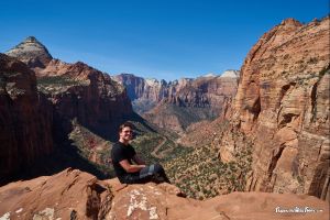
Zion National Park
Zion National Park is located in the Southwestern United States, near Springdale, Utah. A prominent feature of the 229-square-mile (590 km2) park is Zion Canyon, which is 15 miles (24 km) long and up to half a mile (800 m) deep, cut through the reddish and tan-colored Navajo Sandstone by the North Fork of the Virgin River. The lowest elevation is 3,666 ft (1,117 m) at Coalpits Wash and the highest elevation is 8,726 ft (2,660 m) at Horse Ranch Mountain.
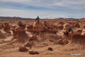
Goblin State Park
Its eminent feature is its thousands of hoodoos and hoodoo rocks, referred to locally as "goblins", which are formations of mushroom-shaped rock pinnacles, some as high as several meters. The distinct shapes of these rocks come from an erosion-resistant layer of rock atop softer sandstone. Along with Bryce Canyon National Park some 190 miles to the southwest, Goblin Valley State Park is one location with some of the highest occurrences of hoodoos in the world.

Arches National Park
Arches National Park is a US National Park in eastern Utah. The park is adjacent to the Colorado River, 4 miles (6 km) north of Moab, Utah. It is home to over 2,000 natural sandstone arches, including the world-famous Delicate Arch, in addition to a variety of unique geological resources and formations. It contains the highest density of natural arches in the world.
The park consists of 76,679 acres (119.811 sq mi; 31,031 ha; 310.31 km2) of high desert located in the Colorado Plateau. Its highest elevation is 5,653 feet (1,723 m) at Elephant Butte, and its lowest elevation is 4,085 feet (1,245 m) at the visitor center. Forty-three arches are known to have collapsed since 1977. The park receives on average 10 inches (250 mm) of rain a year.
The park consists of 76,679 acres (119.811 sq mi; 31,031 ha; 310.31 km2) of high desert located in the Colorado Plateau. Its highest elevation is 5,653 feet (1,723 m) at Elephant Butte, and its lowest elevation is 4,085 feet (1,245 m) at the visitor center. Forty-three arches are known to have collapsed since 1977. The park receives on average 10 inches (250 mm) of rain a year.

Monument Valley
Monument Valley (Navajo: Tsé Biiʼ Ndzisgaii, meaning valley of the rocks) is a region of the Colorado Plateau characterized by a cluster of vast sandstone buttes, the largest reaching 1,000 ft (300 m) above the valley floor.[1] It is located on the Arizona–Utah border (around 36°59′N 110°6′WCoordinates: 36°59′N 110°6′W), near the Four Corners area. The valley lies within the range of the Navajo Nation Reservation and is accessible from U.S. Highway 163.
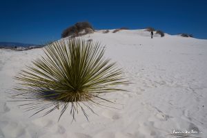
https://en.wikipedia.org/wiki/White_Sands_National_Monument
White Sands National Monument is a U.S. National Monument located in the state of New Mexico on the north side of Route 70 about 16 miles (26 km) southwest of Alamogordo in western Otero County and northeastern Doña Ana County. The monument is situated at an elevation of 4,235 feet (1,291 m) in the mountain-ringed Tularosa Basin and comprises the southern part of a 275 sq mi (710 km2) field of white sand dunes composed of gypsum crystals. The gypsum dune field is the largest of its kind on Earth.
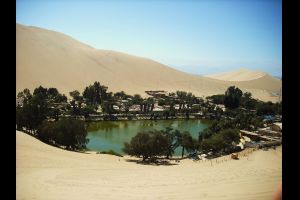
Huacachina sand dunes
Huacachina is a village in southwestern Peru, built around a small oasis surrounded by sand dunes. It is in the Ica Province, about five kilometers from the city of Ica in the Ica District.[1] The oasis features on the back of the 50 Nuevo Sol note. Huacachina has a permanent population of around 100 although it hosts many tens of thousands of tourists each year.